Twin Falls, Yoho National Park – A Backpacking Weekend

IMG_8077 ed

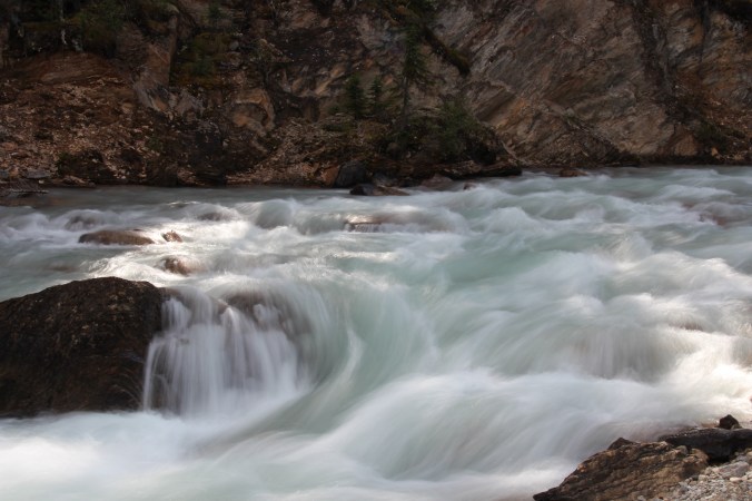
Playing with slow shutter speeds – so glad I hauled my tripod in my backpack!

My friend Jody loves hiking but had never backpacked before so I picked an easier weekend route so she could try it out without me breaking her. This last part was particularly important. If I broke her she probably wouldn’t want to go again. We also needed a route where we could do the whole thing in two nights because she couldn’t take time off work. After looking at routes in the Monashees, Manning Park, and other areas close by I discovered Twin Falls in Yoho National Park and realized it would be perfect, and it was. 20160812_134625

I reserved for one night at the Twin Falls backcountry campground but the Takakaw Falls campground, a ‘sort of’ front country campground, can’t be reserved. When I talked to Parks Canada staff ahead of time they thought on a hot Friday in August it might be full by 2:00 pm or so. As a result, Jody and I were out the door by 6:00 am to make sure we got a spot.

We got there by about 11:30 and proceeded to get

IMG_7717

Takakaw Falls

a bit lost. Parks Canada isn’t known for their excellent signage. We got to the falls and drove through a maze of small roads crowded with cars and tour buses. Then we went through a parking lot that indicated it was for overnight parking but we couldn’t find the entrance to the campsite. We continued driving, thinking it would be further ahead, but ended up accidentally driving 10K back to two incredibly tight switchbacks on the main road before we turned around and tried again. It was only when we saw two people with big black wheelbarrows that we asked about the campsite. It turns out it’s not like most front country campsites in that you don’t park at your site. The campsites are about 500m from the parking lot. Now it made sense. We walked in and grabbed a site, leaving my jacket there to mark it. There is no attendant there, it’s all self registration. Now that we had that cleared up we set up camp and went for a walk to Takakaw Falls. There were tonnes of people visiting the falls but it was nice to get out and stretch and the falls and the river were spectacular.

The Takakaw Falls campsite has no map so it’s hard to see where there are empty spots and a lot of people were wandering around looking for space when we got back. We were very glad we got there when we did. The campsite is a good spot to stay for a few days and enjoy day hikes to Twin Falls, Laughing Falls, Yoho Valley, and the Whaleback. The campsite has running water that is drinkable and bear lockers, which were a nice feature.

Since it was hot that weekend we got up early the next day and set out for the Twin Falls campsite. It was only a little under 7Km so we took our time and enjoyed the amazing views. Basically any time I’m near water I’m a happy camper and the gorgeous white rapids we were following made my heart sing.

One of the small side trails led to the Angel’s Staircase. The trail was a bit muddy and we had to crawl over some logs so we decided not to continue with it. If we felt like it we could try on the way back. We got back on the trail and made our way up the steepest part to Laughing Falls. This part of the trail was a long uphill that looked like it was never going to end but I think it was only two kilometers or so. We saw lots of day hikers along that part of the route.

When we got to Laughing Falls, about 4 Km in, we were delighted. There is a lovely campsite there so we took off our packs, had lunch, met the Parks Canada warden who checked our trail passes, and enjoyed what is to me one of the most perfectly designed waterfalls ever. Good job mother nature! The falls are wonderful and it would be very well worth a day hike from Takakaw Falls. We pumped some water – Jody’s first time doing it, and kept going.

The trail is a bit steep but in no time we were making a short descent into the Twin Falls campground.

I think the Twin Falls campground is one of my favourite campgrounds ever. There are only maybe 10 sites and they are tucked in the trees so they feel very private even though they are close together. They are also right next to the river and the cooking / eating area. Nothing like Egypt Lake that required a hike to get to anything. The river itself is spectacular, a cascading series of rapids in a picturesque location. The sound of the water created a soothing backdrop that made everyone at the site, all friendly and relaxed, want to sit out at the picnic tables and just stare at the view. People talked, played cards, read, wrote, and enjoyed the good company and the beautiful scenery. I loved it. I could easily make the short(ish) hike to that site and stay for a few days just reading and writing.

The only problem I have with the campsite is the outhouse. It was pitch black, even in the middle of the day. We noticed the same thing at Laughing Falls. It’s not rocket science Parks Canada! Just poke some small holes in the top along the sides! I shouldn’t need a head lamp to go to the washroom on a bright sunny day!

Once we set up camp we made the 1.1 km hike on the steep uphill trail to Twin Falls. We had thoughts about doing the Whaleback trail, which would have been a few hours on extremely steep trails, and decided to save it for another time. It was hot and remember, I was trying not to break Jody. The hike up to the falls was enough. When we got there we decided to treat ourselves to tea at the Twin Falls Chalet.

The Twin Falls Chalet is a delightful oasis in the middle of the back country. It’s a historical gem and it’s perfect that you have to put in a bit of work to get there. The only way you can enjoy its wonders is to hike in. Originally built by the CPR as a tea house in the early 1900’s, the chalet has been operated by Fran Drummond since 1962. She and her staff treat guests to what I would call ‘rustic hospitality’ and it was one of the most memorable places I’ve ever been to. While we didn’t stay there, we did go in and enjoy the best butter tarts I’ve ever had – cooked on a wood stove. I had lemonade and Jody had tea. It was perfect. Then we explored the falls for a while before heading back down to our campsite. If you go, make the effort to go in and enjoy the atmosphere. It’s a bit pricey but since they backpack most supplies in, with some brought in by helicopter as well, it’s completely worth it.

The falls themselves are enormous and beautiful. I was really glad I had hauled my tripod on this trip. I took over 500 photos over the 2 days.

When we got back down to the campsite we soaked our feet in the icy water for awhile. I got foot freeze after about two seconds. This is similar to brain freeze but it happens in my feet. Jody has more tolerance for foot freeze than I do because she stayed in a lot longer. I just kept dipping my feet. We pumped more water and she read while I wrote and took pictures. The afternoon was hot and sunny and it was perfect. We had a nice hot supper and enjoyed the evening on the rocky beach before going to bed early.

It rained overnight but the weather was nice going out. It seemed to take us no time to get back to the car and we even stopped at Laughing Falls again for a snack and more pictures (just in case the first 100 didn’t turn out… right???).

We were back to the Takakaw Falls campsite by about 10:00 am and back in Kamloops by 3:00 pm. It was a great weekend getaway and Jody is already planning more trips for next summer.

Edited: I forgot to mention our outstanding wildlife sightings – 2 squirrels, 2 chipmunks. Good thing we were carrying bear bells, bear spray, bear bangers, bear bags for food, etc.!


Egypt Lake (Banff) – solo backpacking is now an annual crazy thing

IMG_7050Last year I did my first ever solo backpacking trip – actually, it was my first ever backpacking trip. I did the 44 Km return trip to Berg Lake in Mt. Robson Provincial Park. It was amazing, life changing, and hard. After I got home, I decided that I needed to do at least one solo trip like this every year. I thought I’d do Berg Lake again this summer, but I couldn’t confirm my dates and then by the time I could the campsites were all booked up. So I decided to explore other areas and in my research I came across Egypt Lake in Banff National Park. It was about 28 Km round trip and it seemed like a good place to explore on my own. I’m back now and I’m extremely glad I did it, but I have to admit it was a lot harder than I expected.

If last year’s Berg Lake trip had a theme of escaping and trying to lighten a heavy heart, this year was about chasing the unknown.

Growing up we always drove by Banff on our way to Calgary or Saskatchewan but we never stopped. Everything on this journey was new.

When I was researching the trip, I found very little information on Egypt Lake. Some descriptions called the hike very strenuous, some said it was moderate. For future reference I would definitely call it strenuous.

From the start I felt less organized than usual – where to go, where to get my park pass, what the trail would be like. Normally I’m the person who has all my information colour coded on a spreadsheet and cross referenced for extra measure. This time I was oddly free-flowing. About a month before I fell while trail running and had a sprained knee that was swelling and stiff at the end of every normal day. Because of that I realized when I got there that I hadn’t actually put my hiking boots on since last fall – this is very unusual for me.

I treated myself to new equipment this year. I now have a super cool Marmot Limelight 2 person tent, a Northface Furnace sleeping bag, and an Osprey 65L backpack that I had fitted by my go to person, Lisa Palechuk, at Atmosphere. It turns out my back is shorter than I realized and I’m actually an EXTRA SMALL in back length. I put that in all caps because I’ve never ever been called extra small in anything. This is possibly not where I wanted to start. I also invested in a Gem Trek Map of Banff and other areas.

Thanks to Lisa, I also had her modify my sleeping bag and sleep sack. She owns Osprey Custom Sewing and used some great creative sewing talent to devise a system for attaching my sleepsack to my sleeping bag so I wouldn’t be spinning like a tornado inside my sleeping bag, unable to move and trussed up like a mummy. It’s a brilliant system with velcro and hooks and worked great. More on that in another post.

I prepped all my food, enjoying dehydrated beef chili, dehydrated spaghetti and meat sauce, marinara sauce, and a yummy breakfast of dehydrated mashed potatoes, cheese, and bacon. I even made a dehydrated version of pineapple upside down cake. More on these in another post too.

Day 1 – Kamloops to Banff

It poured rain the whole way to Banff and trying to find parking in town to get my park pass at the visitor centre nearly made me want to turn around and come home. After missing the turnoff to the campsite I was truly frustrated and this is not my normal state. I stayed at the Village 1 front country campsite just outside of Banff the night before I set out on the trail.

Day 2 – Banff to Egypt Lake

It had rained for days and when I set out the next morning to drive to the Sunshine Ski Resort gondola parking area it was coming down in buckets. I was not enthused. By the time I parked, however, the rain had cleared and I had a lovely day for hiking on a very muddy trail.

Leaving from the gondola area, the hike to Egypt Lake is about 12.5 Km. The first 9 Km is  uphill. The trail itself was well maintained with good bridges for stream crossings and really good footing. It’s also really, extremely, boring. It’s just a long tree-lined trail with tall trees that block any view of the mountains. Nothing changes, there are no landmarks except for the Healy Creek campsite about 6 Km in. You just keep walking uphill (with a heavy pack). After about 5 hours, however, the trail opened up and suddenly I was very, very aware I was in the Rocky Mountains. I could see peaks all around me and the wildflowers were in an explosive bloom – it was almost too much to take in.

IMG_7016


From the top of Healy Pass you can see about 70 Km of the Great Divide including Mt. Assiniboine and other spectacular peaks along the north end of the Monarch Ramparts. It was really breathtaking and I was in absolute awe.

When I looked in the other direction, I could see Egypt Lake far below me, and what I didn’t realize – Scarab Lake was right above it with a waterfall draining from Scarab to Egypt. It was amazing and I wasn’t expecting it. None of my research had uncovered this view.

IMG_7052 ed

The last few Km are straight down to the valley below. This is a knee and toe punishing route that is really steep and hard on the legs at a time when the legs might already be a little tired from the long uphill to get there.

I finally made it to the campsite 7 hours after I started. I am usually pretty slow but most of the guides say it will take between 6 and 7 hours. When I got to the campsite, though, I was done. I set up the tent and crashed for a bit. There is a bare bones shelter cabin at the campsite that hadn’t been booked for the night so some other campers and I decided we should all cook inside and stay out of the cold – it was really chilly that first night. We had a great time. There was a couple with two  young kids from Cranbrook and another couple from Saskatoon and me. It was a lot of fun. I did some writing in my tent and went to bed early after hanging my food in the shelter.

Day 3 – Egypt Lake

IMG_7057

The Egypt Lake campsite is a popular place to set up a base as there are a number of trails that intersect at the site making it great for day trips. Everyone told me the hike up to Scarab Lake was steep but offered a really great view of the lake above and the waterfall that flows below into Egypt Lake. From there you could do a ridiculous 1-2 Km (reports vary wildly) scramble over boulders to Mummy Lake. I decided to skip that hike and rest my toes and knees and just hung out at the lake, which is about 800 m from the campsite. After all, it was my holiday and I could do what ever I wanted. I spent the morning at the lake and took hundreds of pictures. I came back after and flopped in the tent, laughing evilly at the squadrons of mosquitoes and flies that were trying to get in, and let my mind wander. I ended up working on a screenplay idea I wasn’t expecting to work on and really getting into it so that was interesting.

The campsite itself is a bit underwhelming. It sits at the base of Pharoah Peak, which is impressive, but it is very marshy so if you step off a trail you end up ankle deep in water. There are lots and lots of Hoary Marmots for entertainment and I listened to countless bird songs that I didn’t recognize. The place where you hang your food is a good 3-400 m from the campsites which is good to keep bears away but it sucks if you want a snack. They have a great cable system though which makes hanging the food, cookware, and toiletries pretty easy. About 300 m in the other direction is Pharoah Creek, the nearest location for water. With the lake 800 m in the third direction, this campsite is very spread out. One woman commented that if she had to walk that far to the fridge at home for a snack she would be much thinner. I agreed.

I was beginning to realize how spoiled I was at Berg Lake last summer – the lake was right at the campsite. You could hear the glacier calving all night. The bear lockers and cooking area were nearby. There was always plenty to see and do.

I noticed the steep downhill had made the ends of my toes a bit numb and I was worried I was going to lose toenails – not a big deal – it happens sometimes with half marathons. Just not very attractive but it’s not like a have a crowd of people looking at my feet.

That whole day I made of point of not rushing. It was nice and sunny. I slowed down, I noticed a bird, a Spotted Sandpiper, at the lake that wouldn’t leave me alone and it absorbed my attention. The ‘should’ in me said if I came all this way I ‘should’ hike to Scarab Lake, blah blah blah. Instead my mind took me to that screenplay idea that was pretty much plotted out by the end of the day.

Day 4 – Egypt Lake to Kamloops

Well, the day started OK.

While at Egypt Lake several other backpackers told me about the Simpson Pass route to return on. They all said it was more interesting and less of a steady downhill. I could get a burger in Sunshine Village and then take a shuttle bus down to the gondola parking lot. The weather was supposed to be nice so I planned to do it.

My biggest worry (ahead of time) was the 3 Km straight up to the Healy Pass summit. Really, though, I should know better. Hard goals that are clearly defined are easy for me to get my head around. I put one foot after the other, stop and rest when I need to and then keep going. Such a good metaphor for life. Such a great feeling when I accomplish the goal.

I got to the top of the pass in 2 hours and I was pretty pleased with myself. I met a group of guys from Utah at the top. They were half way through a 100 Km trip and were taking the Simpson Pass route too – they heard the burgers calling. I took group pictures of them at the top and we parted company.

Simpson Pass:

I could see the rain clouds approaching when I got to the top but I hoped they would hold off. I went down through the wildflowers again and reached the junction where the Healy Pass and Simpson Pass trails met. I could have taken the easy, known, less interesting route that I had come up but I chose to take the other trail and it became my adventure. I didn’t take as many pictures  – misery doesn’t make me feel very creative.

The Simpson Pass trail was not as well defined as the Healy Creek trail. It was narrower, muddier, with no bridges across streams – just slippery rocks. I had the sense I didn’t know where I was going because I had no idea what to expect – no landmarks to go by. I just kept going and trusted the process. As the trail moved on I met more and more people so even though I did know I was on the right trail, I still felt a bit of panic. I hadn’t planned on this trail so I was out of my comfort zone. I’m not one for just going with the flow without a plan.

As I continued the trail started to get worse. It was steeper (up and down) and muddier which made it slippery. The weather started to get worse and was soon full blown rain. As I went up and down steep and tall ridges, my knees and toes were protesting mightily.

The thing that was most frustrating was I had no sense of how far along the trail I was or how far I had to go. I would ask people and feel somewhat reassured, but I was out of my element. I like to know and I’m not big on surprises.

At one point, with about 5 Km to go, I was moving along a steep and narrow part of the trial when I encountered a group of six or seven people who changed my outlook completely. The trail was narrow, running alongside of a mountain. It was really muddy. They were pushing and carrying a woman in a TrailRider. I had seen these on TV before, but not in real life. The trail was difficult and they were coming toward me. They would have been about 5 Km from Sunshine Village at that point. Having a heavy pack I take up a lot of room so we all carefully squished and squeezed so I could get by. I was amazed at their commitment – they all went through a lot of effort to give this woman an amazing mountain experience. It was pretty humbling. Here I was in my head stressing about the trail and they were moving this huge contraption through the same mud, up and down the same slopes, and over the same streams. Suddenly my problems seemed a bit smaller.

For the rest of the trip my head would start to complain again and just as that whiny voice would get louder in my brain, I would look down and see the track of the thick tire of the TrailRider. Humbled again.

I passed by three large red cones mounted into concrete and realized I was right at the Alberta / BC border. This was kind of cool. Around this point the trail seemed to disappear and go in all directions thanks to some runoff areas because of the rain. When I calmed my mind, though, I could see the trail and then I would see hikers coming toward me and I felt relieved again.

Eventually, the rain cleared and I saw something that pretty much made me want to cry. At the top of a nearby peak I saw a chairlift… something man made… something related to a ski village! The trail improved dramatically and there were day hikers all over the place. I walked down a steep snowshoe trail for 1.6 Km apologizing to my toes all the way. Finally I was there. I took my backpack off and left it outside, bought a ticket on the Shuttle, and ordered a burger, ginger ale, and fries….. heaven!

When I got down to the village I ran into one of the guys from Utah. His leg was bleeding. It turns out he had slipped and fallen on one of the steep inclines in Simpson Pass. Both of us admitted the trail was a lot harder than we were expecting.

I had planned to do two nights at Johnston Canyon but with more rain in the forecast and my knees and toes complaining, I decided to go home… it was my holiday and I could do whatever I wanted.

Although my knee was swollen and my toes were numb (updated report… 3 toenails probably toast) I felt pretty good the next day and decided to do something decadent on my holiday. I drove from Kamloops to Vancouver to visit a used bookstore.

I love holidays!

Looking back, this trip was about being OK with being uncomfortable. I like to have everything in my life planned and controlled. I like to control my surroundings. This was good practice at not being able to control my surroundings and just going with what was happening all around me. Very valuable and powerful.  I’m not sure I’d do Egypt Lake again. There are other trails in Banff, Yoho, and Waterton I’d like to tackle and I love Berg Lake so I know I’ll do that one again. I think it was a gorgeous place to go but I’m not sure it’s my go to place – that’s still Berg Lake.

Next up is a quick backpack in Yoho with a good friend. This will be the first time I’ve backpacked with someone else – I can’t wait!